The Heights Primary was established to serve the west side of Caversham, specifically the Caversham Heights area. The closest schools currently serving this area are Caversham Primary, The Hill and Emmer Green Primary, all of which are heavily oversubscribed (i.e. they receive many more applications than places available). Consequently only those children living closest to these schools are offered a place, and many children fail to be offered a place, even though they are technically in the catchment area.
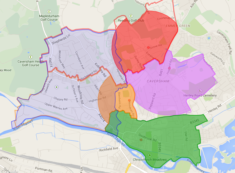
The catchment area for The Heights was defined through analysis of reception intake data between 2007 and 2013 as well as projected intake numbers from RBC to establish the area served by the closest existing schools. The analysis showed that these schools do not adequately cover Caversham Heights. This is evident from the map below which shows the furthest distance where a reception place was offered in the years of least coverage for reception children living in the Caversham Heights area:
Map 1 – The Height’s catchment compared to bordering Caversham schools’ admissions
Notes
1.The blue border shows The Heights catchment. The eastern boundary of the catchment area was based on previous and projected locational shortfalls from Caversham’s existing schools, using expert advice from RBC. The remaining boundaries were defined by the Oxfordshire Country border (to the north and west) and the River Thames (to the south).
2. The orange area represents the location of reception places offered by Caversham Primary based on an intake of 60 pupils in 2011.
3. The red area represents the location of reception places offered by Emmer Green Primary based on an intake of 60 pupils in 2013.
4. The purple area represents the location of reception places offered by The Hill of 90 pupils 2014. This is despite including an addition bulge class of 30 pupils for that intake.
5. The green area represents the catchment area of Thameside which was oversubscribed in 2014. We have been unable to obtain data to show how close to the school the furthest pupils live, but all live within the school’s catchment area.
6. The orange and red borders represent the catchment areas of Caversham Primary and Emmer Green Primary respectively.
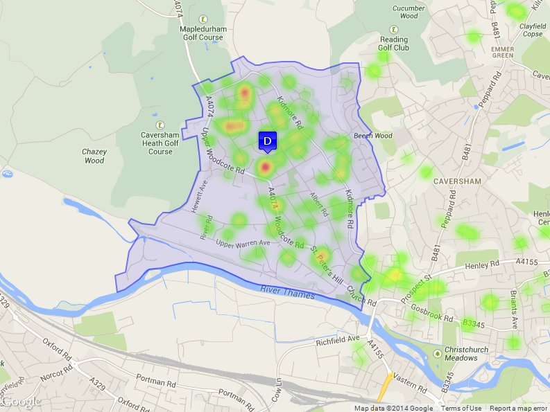
Defining the data point
In the absence of a permanent school location, a geographical point within the catchment area (known as the “data point”) was required to administer the admissions criteria should The Heights Primary become over-subscribed. The Heights Trust, working closely with the admissions team at RBC, derived the data point by weighting the geographical centre of the catchment area with the location and spread of the demand data collected as part of the Evidence of Demand survey required by the DfE. This was accepted and included in the admissions packs for the September 2014 entry.There are no plans to change the data point once the school moves to its permanent location.
Map 2 – The Heights’ catchment, data point and heat map showing the Evidence of Demand results
Notes
1. The blue area represents The Heights catchment.
2. The “D” indicator represents the data point.
3. The coloured spots are based on the Evidence of Demand survey and represent the addresses of children whose parents said they would select The Heights for one or more of their children.
4. Several children in close proximity are represented by heat spots with the red spots showing the greater concentration of demand.
Conclusion
Both the evidence of demand survey and the admissions data from RBC indicate a severe shortage of school places in the Caversham Heights area. The total shortage of school places in Caversham impacts the western side (Caversham Heights) most severely due to the locational imbalance of the existing schools, which are wholly situated in the East of Caversham.
The DfE looked at their own data regarding school places and future demand in the area to satisfy themselves that they could agree with the analysis from the Trust and RBC. They instructed the EFA to find a suitable location for the school in the Caversham Heights area.